Samstag, 28. April 2012

Double Flight


On 27 April, we performed two flights in a row. The flight track was the same for both flights. A few mid-level and a closed deck of low-level clouds was observed on the first flight. On the second flight in the afternoon, both layers were already dissolving. It will be interesting to compare these two development stages in the data.
A closed layer of low clouds before noon
The same layer dissolving in the afternoon,
revealing the sea ice under it

Freitag, 27. April 2012

Weather Forecast for Inuvik from Leipzig students

Weather Forecast for Inuvik, Canada

Date: Friday, April 27th, 2012

General Weather Situation:
A low pressure system over the Gulf of Alaska moves toward the northeast and weakened further to the west coast from Canada. At the same time a high wedge is over the North American continent to the Arctic Ocean. To the northwest of Inuvik, a low pressure area is generated, which will deepen in the course of the weekend.

Further course of the day:
After a foggy night, the gloomy weather will hold during the day. Out of the fog, it can snow in the late afternoon light scattered. The temperatures after a cold night at -12 ° C increases day by up to values ​​of -4 ° C. The wind is blowing from the northwest while weak.

Weekend weather:
At the weekend the aging low draws from the Pacific coast across northwestern Canada. Furthermore, it will unite with the generated low over the Beaufort Sea.
After foggy early Saturday, there will also later in the day be no change in the weather, leaving it dry. It was not until Sunday afternoon, the sun is expected to show again. Temperatures range from -12 ° C at night to about -3 ° C during the day. The cyclonic wind shifts on the weekend from northwest to east.

Further outlook:
After the meantime weak gradient, there will be a new low pressure area north of Alaska closer to the continent, which will lead to renewed motion for Inuvik weather.


© LIM, erstellt von Martin Schmidt

This was the last weather forecast from Leipzig students.
Have a good time!

Donnerstag, 26. April 2012

The end of the line

When a supply helicopter dropped its goods right onto the one glass fiber that connects Inuvik to the outer world, we had the chance to experience life without internet and telephone for a day. Right now, it is all back working. Today's flight, however, was cancelled due to low clouds and poor visibility at Inuvik airport.

Weather Forecast for Inuvik from Leipzig students

Weather Forecast for Inuvik, Canada

Date: Thursday, April 26th, 2012

General Weather Situation:
Inuvik is still under the influence of an upper-level ridge which moves eastbound and hence clears the way for a newly established upper-level trough above the Arctic Ocean. To the west there is an ageing low pressure system in high air layers. On the ground high air pressure with a low pressure gradient is persistent.

Course of the Day:
Thursday is characterized by medium cloud coverage. Towards the evening it will be clear. Flurries in the morning and afternoon cannot be excluded. Light winds blow steadily from the northwest. The temperature will vary between -10 and -4°C (14 to 28°F).

Forecast for Friday, April 27th, 2012:
Friday will start with a cold temperature of -15°C (5°F). Throughout the day the values will not exceed -5°C(23°F). In the morning fog depositing rime is possible and will probably not thin out so that there will be clouds all day long. But sunny intervals can occur, too. There won't be any snow on Friday. The wind remains unchanged in direction and force.

Forecast for Saturday, April 28th, 2012:
At the beginning of the day there will be a temperature of -12°C (10°F) and an overcast sky. Towards the evening it will become sunny so that as a result we will reach -4°C (25°F) in the afternoon. There will still be light winds blowing from northwesterly directions. Flurries are possible during the course of the day.

Further Outlook:
The newly formed upper-level trough above the Arctic Ocean will intesify but won't have an impact on the weather in Inuvik just yet. On the ground the polar cold high remains and leads to sunny following days. Because of the weak pressure gradient the wind will continue to blow lightly.

© LIM 2012, Sarah Grawe


Mittwoch, 25. April 2012

Weather Forecast for Inuvik from Leipzig students

Weather Forecast for Inuvik, Canada

Date: Wednesday, April 25th, 2012

General Weather Situation:
Northern Canada is under the influence of an upper-level ridge which borders on an ageing low pressure system in the west above the Gulf of Alaska. The cold high on the ground and the high pressure in upper air layers are decisive for Inuvik.

Course of the Day:
After a cold night with a temperature of -15°C (5°F) the day will be consistently sunny with values around -3°C (27°F). In the evening it will cool down quickly due to nonexistent cloud coverage. It will remain dry. Light winds will blow from easterly directions throughout the day.

Forecast for Thursday, April 26th, 2012:
Towards Thursday the upper-level ridge will shift eastbound and an upper-level trough will develop above the Arctic Ocean. On the ground, though, high pressure will persist. After -15°C (5°F) at sunrise the day will beginn clearly and the sky will continue to be free of clouds in the following. The temperature will reach -5°C (23°F) and there won't be any precipitation. The wind will blow lightly and change its direction to northwest during the night.

Forecast for Friday, April 27th, 2012:
In the early hours on Friday fog depositing rime is possible and may not thin out throughout the day. For that reason the temperature will only vary within a small range between -9°C (16°F) and -6°C (21°F). Light snow showers may occur during the day. There will be a soft breeze from northwesterly directions. 

Further Outlook:
The next few days will be characterized by the influence of high air pressure which will be replaced by a low pressure system moving in from Alaska towards the end of the weekend. Because of a weak pressure gradient eventual fog may occur together with snow showers at daytime.

© LIM 2012, Martin Schmidt

Dienstag, 24. April 2012

One kind of bear is everywhere

Who ever said that licence plates have to be rectangular?

Third flight, 23 April

A pingo in the snow.
We headed out north-west for another sea-ice study. Unfortunately, continuous low clouds made it impossible to deploy the EM Bird this time. Instead, we probed a haze layer which the mass spectrometer detected at around 2400 m altitude. On the way back, we could see a few pingos near Tuktoyaktuk, hills created by the permafrost.

Second flight, 22 April

The EM Bird is installed under
the aircraft belly.


Thin ice on a re-frozen open lead in the ice.

The ice looks fascinating from
this close perspective.
The EM Bird is monitored by a video camera.
Here you can see it in the top center.
A successful flight for the sea-ice studies was conducted today over the Beaufort Sea. The EM Bird is an electromagnetic sonde that uses the conductivity of sea water to detect the bottom of the sea ice. The top of the ice is observed with a lidar altimeter, and the difference is the sea-ice thickness. For these surveys, the aircraft flies 65 meters above the ice, at 55 m/s, and the Bird is towed on a 200-ft rope so it is near the ice.

Weather Forecast for Inuvik from Leipzig students

Weather Forecast for Inuvik, Canada

Date: Tuesday, April 24th, 2012

General Weather Situation:
Northern Canada is still under the influence of a low pressure system above the Aleutes which is moving westwards and will combine with another low to the south of Alaska. Furthermore the polar high continues to be located in the Arctic region and has an effect on the weather in Inuvik even if there is barely any movement of air masses noticeable.

Course of the Day:
In the morning there is a chance of fog which will thin out until noon. Afterwards it will be sunny but from time to time medium high cloud banks will move across the sky. It will remain dry. After a cold morning with a temperature of -11°C (12°F) we will reach values of just above freezing. In the evening it will cool down quickly due to little cloud coverage. The wind blows lightly from easterly directions throughout the day.

Forecast for Wednesday, April 25th, 2012:
Initiated by subsiding air masses, clouds will dissolve and the morning will beginn clearly with a temperature of -9°C (16°F). During the day it will remain sunny. The maximum temperature will not exceed the freezing point. Precipitation is not to be expected. There will be light winds from easterly and in the evening from southeasterly directions.

Forecast for Thursday, April 26th, 2012:
In the course of the night the sky will become increasingly overcast. As a result isolated snow showers are possible in the morning and also during the day. The temperature varies between cool -7°C (19°F) at sunrise and not more than -2°C (28°F) at daytime. Starting from the early hours light winds will blow from northerly directions.

Further Outlook:
Towards the weekend the low to the south of Alaska will dissolve. Simultaneously a new low above Northern Canada will establish and intensify. This may lead to further snowfall.

© LIM 2012, Martin Schmidt

We would be very pleased if any of you could send me pictures of the sky of a few times the day. We need this for our seminar because there is no webcam for Inuvik. Thanks a lot!

Montag, 23. April 2012

Weather Forecast for Inuvik from Leipzig students

Weather Forecast for Inuvik, Canada

Date: Monday, April 23rd, 2012

General Weather Situation:
At the moment Northern Canada is influenced by the Aleutian Low to the west of Alaska as well as a thermal high situated in polar regions. An upper level ridge to the east of the Aleutian Low extends to the Northern Territories. However, Inuvik is located in an area affected by a low pressure gradient. As a result there is no distinct weather activity.

Course of the Day:
After a cold night with a minimum temperature of -10°C there will be an increase until just below freezing point which will be reached in the afternoon. Light winds blow from easterly and northeasterly directions. For the greater part the sky will be overcast with sunny intervals around noon. In the evening it will be clear. There won't be any precipitation during the day.

Forecast for Tuesday, April 24th, 2012:
The low pressure system above the Aleutes has moved to the southeast and is now located to the south of Alaska. Therefore Inuvik is influenced by an air flow from southerly directions. In the early hours the minimum temperature will reach -7°C, in the afternoon values above 0°C are possible. There will be a continously gentle breeze from easterly and southerly directions. After an overcast morning it will be sunny with cloudy intervals. It will remain dry again.

Forecast for Wednesday, April 25th, 2015:
During the night the temperature will sink to -7°C and approach 0°C during the day. Light snowfall and a full cloud coverage are likely. The wind will blow gently from easterly directions.

Further Outlook:
Within the next few days the low pressure system to the south of Alaska will shift further south. The development of a new low above Alaska will lead to changing weather.

© LIM 2012, Martin Schmidt
uploaded by mobile

Samstag, 21. April 2012

Flight #1


Flight track in Google Earth with
today's NASA MODIS satellite overlay
A large open lead in the Beaufort Sea
Today at 10:24 (Mountain Daylight Savings Time), that is 1624 UTC, the Polar 5 took off for the first VERDI flight in Inuvik. It was a Bird mission, so we headed onto the sea ice, expecting cloud-free conditions in the target area. But there were low, foggy clouds that were missed on the satellite pictures, so conditions were not good: the clouds decrease the pilots' visibility, and the humidity seemed to irritate the Bird. On the way back, the remote-sensing equipment scanned the low clouds and the sea ice, which has several large open leads, also an interesting topic. The flight ended at 13:53 in Inuvik.

Freitag, 20. April 2012

No flight today

Due to low cloud cover here and over the ice on the Beaufort Sea, our first science flight will not be today. The first few flights will be with the towed EM Bird, which is lowered down to a few meters above the sea ice. That is a tricky manoevre for the pilots, and they need good visibility. Low clouds are a dealbreaker for that kind of mission. Instead, we work on a few more technical issues of our instrumentation.

Arrived


Both the Polar 5 aircraft and the crew have arrived in Inuvik. As you can see in the pictures, we have snow again! From Yellowknife to Inuvik you fly along the Mackenzie River, which is still ice-covered, just like the thousands of lake that speckle the Canadian landscape. We have settled in the Aurora Research Institute's dwellings, and their office buidling is very nice and modern with a well-equipped conference room. Their staff is really nice and very helpful. The main road is ice-free, and we start to find our way around town.

Mittwoch, 18. April 2012

Across Canada


The Polar-5 has left Muskoka in the morning of 18 April, with lots of cargo. It will take them three stops before they get to Inuvik, while the science crew is taking commercial flights via Edmonton.

Take off for test flight

At April 17 the Polar5 took off at 14:00 local time from Muskoka Airport for the test flight.

Dienstag, 17. April 2012

Test Flight

Today (17 April) we accomplished a two-hour test flight starting and landing at Muskoka Airport. Take-off was delayed by snowfall, but by the end of the flight the sky was clear. The instrumentation of the 'Sea-ice' configuration was installed on the aircraft and put to a test in airborne action. The flight was also used for certain calibration procedures. You can see how many circles there were in the flight track, including two at a bank angle of 45°. Funny enough, after completion of such a circle the aircraft encounters its own wake, which could be felt distinctively. The atmosphere was pretty bumpy to begin with, so it was a pleasant ride for those who love rollercoasters. The views of the Lake Huron and of Muskoka's forests and lakes were magnificent. Unfortunately, the test flight also revealed a few faults that need to be fixed.
Samstag, 14. April 2012

Select the app you would like to install

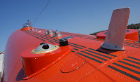
A research aircraft contains many different kinds of instruments. For most of them, some kind of inlet is mounted on the outside and is connected to instruments inside the aircraft. For example, the long tube on the roof is an aerosol inlet that brings aerosol particles to a mass spectrometer in the cabin. In a similar manner, optical fibres guide photons from the sensors on the top and the bottom of the fuselage to a set of spectrometers inside. Some instruments have special windows, like the lidar and the cameras that look through openings in the bottom of the aircraft. Such openings are usually hidden behind roller doors to protect them from gravel damage during take-off and landing. Other gadgets visible on the outside include meteorological sensors, GPS and radio antennas, etc.

Donnerstag, 12. April 2012

VERDI Blog

Welcome to the blog on the international research campaign VERDI (Vertical Distribution of Ice in Arctic Clouds). During VERDI, scientists from various research institutes in Germany will perform airborne measurements in and above Arctic clouds. We will be based in Inuvik, Northwest Territories, Canada, near the Beaufort Sea of the Arctic Ocean. Since 9 April, 2012, the aircraft is being prepared for the campaign at Muskoka Airport in Ontario.